Basics of groundwater flow…
The science and principles of groundwater hydrology and hydrogeology are complex. As a civil engineer involved with water resources, I felt it necessary as part of my research and theory to include a section about the basics of the relationship between rainfall and runoff and how water gets into natural waterway or groundwater systems - which is relative to the contamination component of the research.
The interaction of precipitation, surface water, and ground water involves many physical, chemical, and biological processes that take place in a variety of climatic and physiographic settings. The occurrence, motion, and storage of groundwater are controlled by complicated items such as sequence, lithology, thickness, and structure of earth materials and by factors such as stratigraphy, sedimentation, hydraulic conductivity and porosity. It is not the intent of this website to get into the intense theory behind all of these interacting and fascinating components.
I believe most folks have a general understanding of the water cycle. It is learned in school and by real life experience. Water is constantly on the move. The movement of water from precipitation through a natural or ecosystem is called the hydrologic cycle. Rain, rain drops, rainwater or stormwater - whatever you feel like calling it - prior to becoming groundwater begins as precipitation in the form of fog, drizzle, rain, rainstorm, heavy rainstorms, thunderstorms, hail, snow, sleet, freezing rain, ice storms or combinations thereof.

General graphic of regional or watershed level surface and groundwater flow arrangements (source unknown)
In natural environments, precipitation is slowed down, spread out, soaked in (filtered or absorbed) by plants, or soaks into the ground. Precipitation which is not taken by plants or does not “soak in” to the soil becomes runoff. Runoff of water across the land is usually defined into three different types - overland (or sheet) flow, concentrated flow, or channel flow. The amount of runoff is very dependent on the characteristics of the land surface such as the amount and duration of rainfall, the type of land use, the slope of the land, and type of ground cover conditions present. When the rate of precipitation exceeds the rate of evaporation, evapotranspiration, and infiltration, water will then flow over the surface of the land as runoff. On areas with steep slopes and/or impervious types of ground cover, infiltration is very limited. Impervious surfaces include all types of hard surfaces such as roofs, decks, patios, highways, roads, streets, alleys, driveways, paths, and parking lots. Water on leaves or plants can return to the atmosphere by evaporation. Living vegetation creates water vapor which is released to the atmosphere and is known as evapotranspiration. It can then become precipitation again to complete the entire hydrologic cycle.

The left side of this graphic shows the many ways that trees handle and use precipitation. The right side graphic shows the distribution of rainfall between the processes of evapotranspiration, surface runoff and infiltration for forested land cover. The graphic below shows the two types of infiltration that may occur. (Source: PALS, The Woods in Your Backyard 2015)
The process by which water soaks into the ground is called infiltration. On pervious areas, precipitation falls on the land. Evapotranspiration and initial infiltration occurs until the soil reaches a certain saturation point within the soil (based on characteristics of the soil). Water that infiltrates into the surface soils then begins to penetrate into deeper subsurface soil zones. The rate at which water moves laterally or vertically downward through the soils depends on many factors such as again the characteristics of the soil and the size/amount of air (void) spaces in the soil layers.

Precipitation and runoff supply some of the water that feeds stream, lakes and rivers (for our study streams like Hinckston Run and rivers like the Conemaugh River). These surface bodies of water are also fed by water that is underground - known as groundwater. Underground reservoirs of groundwater are formed by water that seeps down through the soil’s surface and deeper layers to the underlying soil and rocks. This underground water can reappear above ground as springs or seeps and is an important and consistent source of supply to surface waters, especially during dry seasons or during periods of drought.

This very basic diagram of the hydrologic cycle shows the result of precipitation and it’s interaction with vegetation, the land surface, and surface/subsurface soils.

As shown in this simple diagram, precipitation is taken in by canopy, understory and ground cover vegetation or becomes surface runoff or is infiltrated into the surface layers of the ground (soil) and eventually into the groundwater table.

In a stream valley, water from precipitation that is not runoff enters into those soils which are more permeable in the uplands and along slopes - such as Hydrologic Soil Group A and B soils - and by gravity the water works it’s way into the soils and into groundwater and downgradient surface water resources. Just a note here - Hydrologic Soil Groups are designations of soils as defined by the US Department of Agriculture (USDA), Natural Resource Conservation Service (NRCS) in various publications such as Technical Release 55 (TR-55) and in most all County Soil Surveys. The four hydrologic soil groups (HSGs) are described as follows: Group A - soils in this group have low runoff potential when thoroughly wet. Water is transmitted freely through the soil and depth to the water table is greater than 24-inches. Group B - soils in this group have moderately low runoff potential when thoroughly wet. Water transmission through the soil is unimpeded. The depth to the water table is greater than 24-inches. Group C - soils in this group have moderately high runoff potential when thoroughly wet. Water transmission through the soil is somewhat restricted and depth to the water table is greater than 24-inches. Group D - soils in this group have high runoff potential when thoroughly wet. Water movement through the soil is restricted or very restricted and a water table may exist within 24-inches of the surface in this group, (Source: Chapter 630 Hydrology National Engineering Handbook, Chapter 7 Hydrologic Soil Groups)

A very basic diagram showing the relationship of groundwater to the land surface, shallow soils, and a natural down-gradient receiving stream channel/water body.
Below the surface, soils can contain rocks, minerals, and spaces. Spaces are called voids or pores. The voids can hold gases or fluids including underground water that supplies wells and springs. Underground water exists in two zones. The uppermost zone, called the unsaturated zone or the zone of aeration or percolation, contains both air and water in the voids. These are the surficial layers or zones. Below this region is called the saturated zone, where all interconnections, voids and cracks are filled with water. Water within the saturated zones is properly called groundwater. Groundwater occurs in the voids between soil and rock particles like water fills the pores of a sponge. The formation in which groundwater occurs is referred to as an aquifer.

Very basic diagram showing the movement of groundwater through time from the land surface into subsurface soil and rock layers.

A close up view of the interaction of the infiltration of water from the land surface into the surficial and deeper soil layers to the groundwater zone.

General graphic of saturated and unsaturated zones associated with groundwater and the water table (source unknown)
There are two types of aquifers - unconfined and confined. An unconfined aquifer is not bound by constraining beds. The upper surface of the aquifer is not confined and the water table (the height of water in the aquifer) rises and falls as the amount of water in the aquifer fluctuates. A well drilled into such an aquifer is called a water table well. A confined or artesian aquifer is one in which the water is under pressure. A flowing artesian well taps an aquifer where the water is under enough pressure to rise to the land surface without pumping. The pieziometric surface - the level to which water would rise under pressure in a well drilled into an artesian aquifer - stands at some height above the level of it’s upper confining bed. If the potentiometric surface is above the land surface, then the well continuously flows and is called a flowing artesian well.

General graphic of an unconfined aquifer (source unknown)

General graphic of a confined or artesian aquifer (source unknown)
Water seeping down from the land surface and through the soil adds to the ground water and is called recharge water. The recharge area for an unconfined or water table aquifer may include all of the land surface above it. For a confined aquifer, the recharge area is typically less extensive. For both types of aquifers, it is important to protect recharge areas from land-use activities that may contaminate them.
Hydraulic conductivity (K) is a measure of the capacity of an aquifer to transmit water. It is usually expressed in terms of velocity such as feet per day (ft./day). Sometimes the term “hydraulic conductivity” is interchanged with the term “permeability”. Although similar, permeability is an intrinsic property of the aquifer material, whereas hydraulic conductivity depends on not only the size and interconnected nature of the water-filled openings in the aquifer but also the physical properties of the water. Coarse-grained sands and gravels generally have large hydraulic conductivity values and fine-grained clay materials generally have small (lower) hydraulic conductivity values. In addition, the terms infiltration and permeability should not be confused either as they are not the same.
In some areas, small volumes of water may exist above the water table. This water, collected on top of an unsaturated soil or rock area above the main body of groundwater, is called perched water or a perched water table. A perched water table is usually not level, but reflects the surface topography above it with hills and valleys just like the land surface.
The overall natural movement of groundwater is slow and highly depends on the type of soil or rock through which it is moving. However, the natural movement is from upland recharge areas to lowland discharge areas - points where the water table meets the land surface such as springs, lakes, streams and wetlands. From points of recharge to points of discharge, groundwater moves slowly through small openings (voids) in rock and soils and usually in parallel paths called layers. Generally there is very little mixing of water in those layers because the slow movement of groundwater does not create sufficient turbulence for mixing to occur. In addition, the process of “diffusion” is a characteristic where a solute (or element) within groundwater moves from an area of higher potential or concentration to areas of lower potential or concentration. As a result, when groundwater becomes contaminated, the contaminants stay in fairly confined plumes which may take decades or hundreds of years to reach a discharge point and which may be very difficult to detect or eliminate.
If a contaminant is soluble in water and reaches the water table, the contaminant will be transported by the slowly moving ground water. If the source continues to supply the contaminant over a period of time, the distribution of the dissolved contaminant will take a characteristic “plume-like” shape. These contaminant “plumes” commonly discharge into a nearby surface-water body. If the concentration of contaminant is low and the rate of discharge of plume water also is small relative to the volume of the receiving surface-water body, the discharging contaminant plume will have only a small effect on the quality of the receiving surface-water body. Furthermore, bio-geochemical processes may decrease the concentration of the contaminant as it is transported through the shallow groundwater system and the hyporheic zone. The hyporheic zone is the region of sediment and porous space beneath and alongside a stream bed where there is mixing of shallow groundwater and surface water. On the other hand, if the discharge of the contaminant plume is large or has high concentrations of a contaminant, it could significantly affect the quality of the receiving surface-water body. Contaminant residence time (the time it stays) in groundwater is usually long, at least measured in weeks or months, and frequently in years or even decades - even if the source of the contamination is dealt with.
Detecting and assessing groundwater contamination is difficult. It is done by extensive geotechnical investigations (drillings and borings), installation of monitoring wells, and testing and analyses of monitoring well data over time. Once contaminated, groundwater remediation is very costly and difficult requiring additional study and analyses and treatment by techniques such as implementing source control measures, pumping, filtering, etc. Source control measures can include: surface runoff controls, subsurface drains, groundwater barriers, grouting of soils, and/or installation of recharge/discharge wells. It most often involves removing or controlling the source of the contamination, isolating the plume, and collecting-treating-returning the groundwater to the aquifer and in some cases treatment or removal of contact soils. Treatment techniques can be physical, chemical or biological. Post-cleanup always involves implementation of a performance monitoring program, with appropriate field and laboratory testing. Therefore, prevention of groundwater pollution and contamination is always the best approach.
In the series of general graphics that follow below, envision that the stream channel as shown in each of the graphics is Hinckston Run and the Hinckston Run stream valley proper. Also imagine the groundwater layer is the groundwater table below the surface of Hinckston Run and the Hinckston Run stream valley, and the higher topographical areas (hills) adjacent to the stream and stream valley are the hills of the Valley View/Benshoff Hill and Linkville Road sections of central and southern Middle Taylor Township to the left (west) and the Riders (Rosedale) Disposal area to the right (east).

A very basic graphic of the interaction between the hydrologic cycle, the land surface and groundwater (source unknown)

Another very basic graphic of the interaction between the hydrologic cycle, the land surface and groundwater (source unknown)
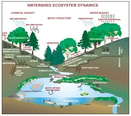
A general color graphic of localized water resource ecological relationships (source EPA Watershed Academy)

Another general color graphic of groundwater and it’s relationship to the entire water cycle, land surface, stream and stream valley (source unknown)

Another general graphic of the relationship between a recharge area (land surface) and groundwater (subsurface). Source of the graphic is unknown.

Another general graphic of groundwater flow characteristics in the localized landscape (source unknown)

Another color general graphic of groundwater interaction directly below a stream channel which is otherwise known as a “thalweg” (source unknown)

Another general graphic of a perched groundwater table within the landscape (source unknown)

Another general graphic of how groundwater can become contaminated from rainfall, runoff and percolation into a resultant groundwater contamination plume (source unknown)


These two final general graphics above show the relationship of a well punched into the groundwater (aquifer) system and the potential relationship of wells to groundwater contamination within the landscape (sources of diagrams are unknown)
For more detailed information about aquifers and groundwater, visit the following:
Basic Education, Groundwater Foundation website at https://groundwater.org/basics/
Federal, EPA at https://www.epa.gov/ground-water-and-drinking-water
State, PA-DNR at https://www.dcnr.pa.gov/Conservation/Water/Groundwater/Pages/default.aspx