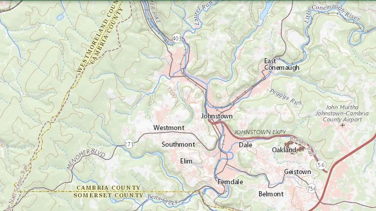
MAP 1 - Vicinity map of the Greater Johnstown area. Middle Taylor Township is just above (north) of where it says Johnstown. The Hinckston Run Reservoir (dam) is above where it says “East Conemaugh”.
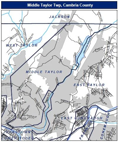
MAP 2 - Township boundary map. Note that Hinckston Run Reservoir (dam) is to the north at the top right of map.

MAP 3 - Road map and route numbers of Middle Taylor Township (source PennDOT).

MAP 4 - Road map and route numbers of the Benshoff Hill/Valley View section of the southern portion of Middle Taylor Township (source PennDOT),

MAP 5 - Topographic map of the site location which is the Benshoff Hill/Valley View and Linkville Road sections and the Hinckston Run stream valley as situated in central and southern Middle Taylor Township, Cambria County (Johnstown) PA.

MAP 6 - General 3-D topography map of the Hinckston Run stream valley with Middle Taylor Township to the left (west).

MAP 7 - General aerial imagery map of where our house was located in the Benshoff Hill/Valley View section of southern Middle Taylor Township and the relationship to the site of the former Bethlehem Steel Corporation Rosedale coke plant and the Riders Dump (Rosedale) Disposal Area. The disposal area is the large grey colored area situated on the upper-right hand (east) side of the map.

MAP 8 - Parcel map of the Benshoff Hill/Valley View section of southern Middle Taylor Township. Our house was the one currently at the location of 222 Taft Street (Parcel No. 40-005.-162.000), the second parcel to the east of the intersection of Taft Street and Castle Street. When we lived there there were no formal street names. Our address was listed as R.D. # 1 Box 377.

Map 9 - Aerial imagery map of our neighborhood in the Benshoff Hill/Valley View section of southern Middle Taylor Township. The house we lived in was the structure near the middle of the page where you can see a bright white roof.

Map 10 - One half mile ring from where our house was in the Benshoff Hill/Valley View section of southern Middle Taylor Township. The Conemaugh River is in blue color in the bottom left hand (southwest) corner of the map. Our house was well within one-half mile of the Bethlehem Steel Corporation Rosedale coke plant.

MAP 11 - One half, one, and one and a half mile rings from the Riders (Rosedale) DIsposal Area along the Hinckston Run stream valley. Hinckston Run Reservoir (dam) is the feature at the top right (northeast) corner of the map. Our house was between the one mile and one half mile distance from the Riders Dump (Rosedale) Disposal Area.