“The industry that was the life-blood and livelihood of family generations before my own created their monopolies and made their profits. In the true spirit against today’s meaning of environmental justice they used our people, consumed our resources, destroyed our environment, and then just disappeared. Not only did they leave, they left quite a contaminated mess behind. This mess has affected and taken the lives of many of my family, friends, and neighbors and caused much damage to the environment. It will last for many future generations.” - - Scott J. Thomas

VICINITY - Shown above is the Greater Johnstown area in southern Cambria County, Pennsylvania. Middle Taylor Township (shown in yellow) is located just north of the Cambria City, Minersville section of the City of Johnstown.

LOCATION - Middle Taylor Township is located just north of the Cambria City, Minersville section of the City of Johnstown, Pennsylvania. On this map, the Conemaugh River is below (south of) Middle Taylor Township. It is shown in blue color in the bottom left-hand corner (southwest) on the map. The crossing of the river at that location is the 4th Avenue bridge at Iron Street sometimes referred to as the Minersville Bridge. The Hinckston Run Reservoir (dam) is situated in the upper-right hand corner of the map (northeast) and the Hinckston Run stream valley comes down through the middle of the map from top to bottom (north to south) from the dam/reservoir and empties into the Conemaugh River.
This website is dedicated to past and current residents of Middle Taylor Township, Cambria County (Johnstown) Pennsylvania. It’s purpose is to chronicle and document more than thirty years of compiled data, information, and research into surface water and groundwater contamination within the Hinckston Run stream valley and it’s effects to residents of the Benshoff Hill, Valley View, and Linkville Road sections of central and southern Middle Taylor Township.
The surface water and groundwater contamination was caused by pollution from industrial wastes and coal refuse dumped at the nearby, upland area known locally as the “Rosedale” dump site. From a regulatory perspective, it is identified as the Riders Dump Disposal Area; however, I will refer to it in this website as the Riders Dump (Rosedale) Disposal Area . This site was the end location for transported and dumped coal refuse, slag, industrial, toxic and other process wastes and materials, and who knows what, from past operations at the Bethlehem Steel Corporation (BSC) Rosedale Coke Plant. The coke plant is now gone - the smokestacks were razed, buildings were demolished, equipment removed, and site soils were remediated through various Brownfield grant programs.
This website provides a summary of research and documentation for information purposes only. It is meant to inform past and current residents of Middle Taylor Township and family, friends, and former neighbors of research and history compiled by the author. It is based on sound science, engineering, and technological research. The purpose statement and goals are listed in the “General” section of the web page.
Important Note: The entire website is set up to view like a book. The best way to navigate through it is to use the menu at the top and logically work your way in order from left to right and also from top down. Start with the “About” section, then go to the “General” section, then go through each of the four “Introduction” and each of the six “Research” sections and end at the “Conclusion”. The five “Image” sections are maps and photographs provided in support of and as referenced in the “Research” sections. The “Epilogue” section is meant to give updates on any progress or inquiries received about this information. A mapping and then three extra and a contact me section are tacked on at the very end for good measure. GOOD LUCK!

LOCATION - This is a general boundary and road map of Middle Taylor Township, Cambria County (Johnstown), Pennsylvania. The Hinckston Run Reservoir (dam) is the large blue color feature shown at the top right (northeast) part of the map. The Conemaugh River is the skinny and windy blue color feature at the bottom left-hand corner (southwest) of the map.

Historical marker dedication in the Cambria City section of the City of Johnstown outlining some of the immigrant history associated with this particular part of the city.

Welcome sign coming into Middle Taylor Township from the south from the Cambria City, Minersville section of the City of Johnstown which is up along the main state road known as Benshoff Hill Road.

A very well-known landmark of Benshoff Hill, Middle Taylor Township is the Pleasant Hill Church of the Brethren (Note: Source of photograph and date unknown).

Perhaps the most famous geographical feature of Middle Taylor Township is a water fall situated just below the Hinckston Run Reservoir (dam). Below the falls, the Hinckston Run stream reforms and traverses in a south direction to Johnstown to empty into the Conemaugh River in the Minersville section of Cambria City in the City of Johnstown. The stream is severely polluted.

Another recognized infrastructure feature of Middle Taylor Township is the Hinckston Run Reservoir and dam (Note: Source of photograph and date unknown).

A serene feature of Benshoff Hill, Middle Taylor Township is the Benshoff Hill Cemetery which is located near the Pleasant Hill Church of the Brethren. Many of my own family members, friends, and neighbors are buried in this cemetery.

This is an aerial image of the Benshoff Hill Cemetery and the Pleasant Hill Church of the Brethren. Benshoff Hill Road is on the right side (Google Earth 2019).

The old “Stutzman” school building in Middle Taylor Township which is where I attended Ferndale Elementary School Grades K through 4. The old school is now the township municipal building (September 2024).

The placard above the door frame of old “Stutzman” school building in Middle Taylor Township (September 2024).
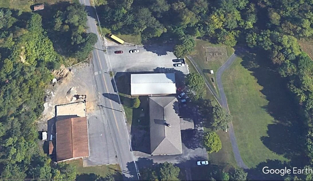
This is an aerial photograph of the Middle Taylor Township fire hall (left - west) and the old school building. Benshoff Hill Road separates the two buildings. The old school is now a municipal building for the township (Google Earth 2019).

This is an amazing vintage rendering of the old “Stutzman” school building and adjacent parking, playground, and sports field area at Benshoff Hill, Middle Taylor Township, Cambria County (Johnstown) PA. I went to this school from K- through 4th grade. This washed view is how I will always remember this school in my mind (Note: source and date of rendering unknown).

Across Benshoff Hill Road at the “Stutzman” school building is the very recognizable Middle Taylor Township Volunteer Fire Company building which has been a centerpiece of the community for decades (September 2024).

Another well-known feature of Middle Taylor Township is the Saint Nicholas Cemetery which is located on a steep hillside adjacent to Benshoff Hill Road just south of the firehall and municipal building (September 2024).


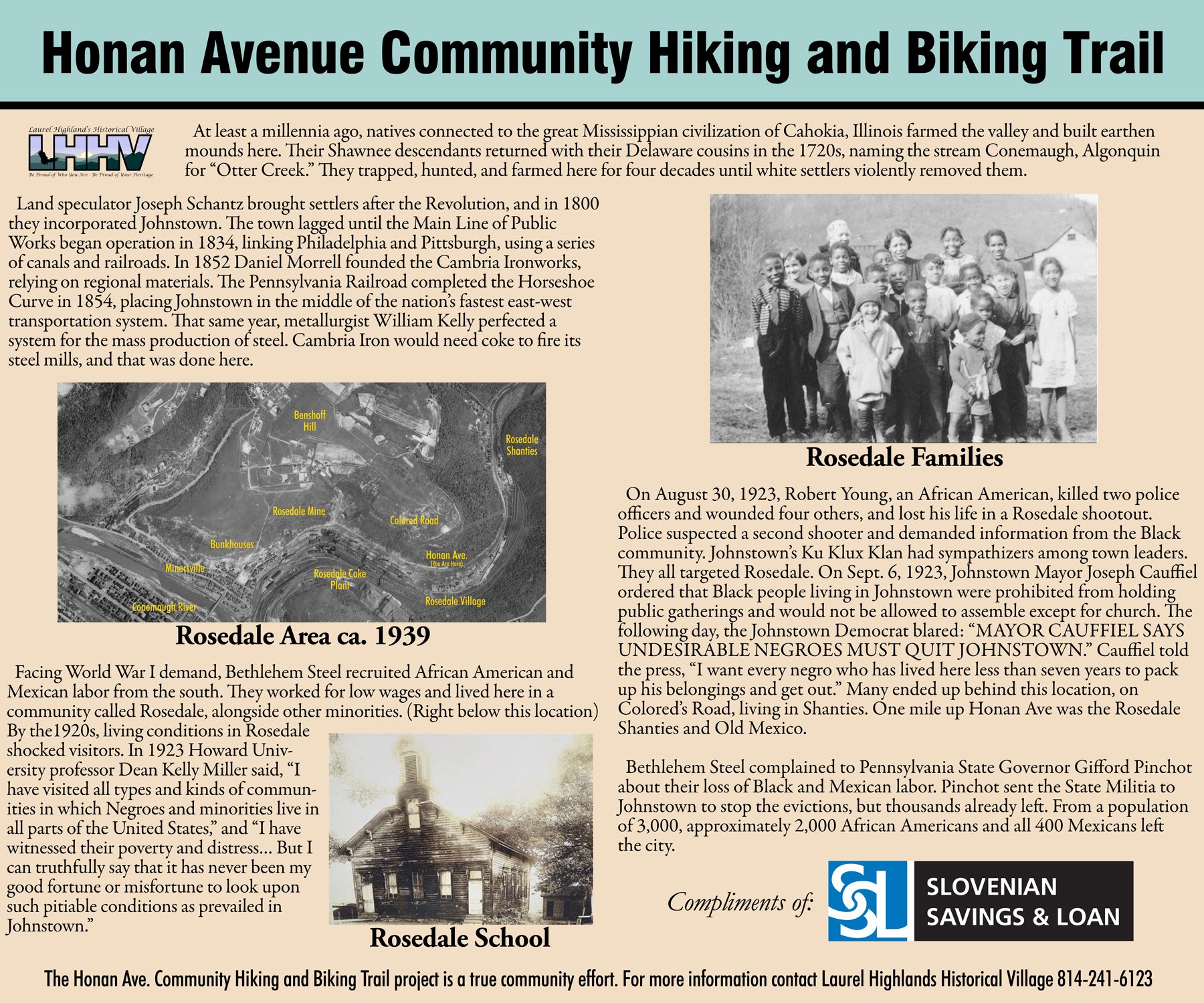
The above three images are provided courtesy of my friend, Mr. Ron Shawley, who is a stringent advocate, steward, and protector of the history and environment of Middle Taylor Township, Greater Johnstown and beyond. He has been instrumental on several successful initiatives in and around Middle Taylor Township including the Veterans Memorial Park at the Hinckston Run Reservoir (dam) and the Honan Avenue Community Hiking and Biking Trail. The above are photographs of commemorative, educational and historical marker signs (courtesy of Ron Shawley) placed along the trail which memorialize the former site of the Bethlehem Steel Corporation (BSC) Rosedale Coke Plant and the plight of minorities associated with the Rosedale Village work camp, shanties and school. For more information, visit the website for the Laurel Highlands Historical Village – Be Proud of Who You Are – Be Proud of Your Heritage (lhhv.org) at www.lhhv.org